Tocht Te voet Lhotka nad Labem - NS Lovoš - Photo

Tous les sentiers balisés d’Europe GUIDE+

© OpenStreetMap contributors
Lengte
Lengte
6 km
Max. hoogte
Max. hoogte
464 m
Positief hoogteverschil
20 m
Km-Effort
Km-Effort  
7,2 km
Min. hoogte
Min. hoogte
162 m
Negatief hoogteverschil
318 m
Boucle
Boucle
Neen
Markering
Markering
Datum van aanmaak :
2025-02-06 22:39:23.799
Laatste wijziging :
2025-02-06 22:39:23.799

(0 Bericht)

Te voet
Te voet
1h38
Moeilijkheid : Gemakkelijk

Scan deze QR-code om de tocht te openen in de SityTrail-applicatie

Gratisgps-wandelapplicatie

Logo SityTrail SityTrail

IGN / Geografische instituten

SityTrail uit de App Store downloaden SityTrail uit Google Play downloaden

Logo SityTrail SityTrail World

De wereld gaat voor u open

SityTrail uit de App Store downloaden SityTrail uit Google Play downloaden SityTrail op Huawei AppGallery downloaden

Over ons

Tocht Te voet van 6 km beschikbaar op Noordwest, Ústecký kraj, Lhotka nad Labem. Deze tocht wordt voorgesteld door SityTrail - itinéraires balisés pédestres.

Beschrijving

Tocht aangemaakt door cz:KČT.

Hoogteprofiel

Foto's

Plaatsbepaling

Land:
Czech Republic
Regio :
Noordwest
Departement/Provincie :
Ústecký kraj
Gemeente :
Lhotka nad Labem
Locatie:
Unknown
Vertrek:(UTM)
430688 ; 5597906 (33U) N.

Wandeltochten in de omgeving

Tocht Te voet Velemín - [Z] Lovosice - Lovoš - Photo
Te voet
GUIDE+

Te voet

Gemakkelijk
Velemín, Noordwest, Ústecký kraj, Czech Republic
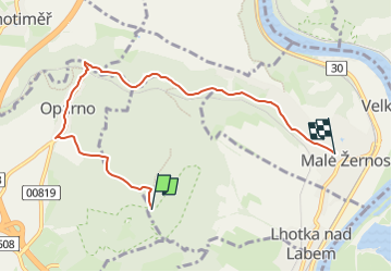
3,6 km | 5 km-effort
1h 7min
Neen
Tocht Te voet Vchynice - [Z] Košťálov - Vchynice - Photo
Te voet
GUIDE+

Te voet

Gemakkelijk
Vchynice, Noordwest, Ústecký kraj, Czech Republic
3,5 km | 5,8 km-effort
1h 18min
Neen


Sluiten
Mijn abonnementen